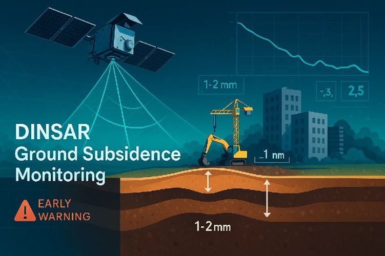
Monitoring ground subsidence with DInSAR has become essential for construction safety and infrastructure protection. This advanced satellite radar technology enables early detection of ground movement, potentially preventing costly structural damage and ensuring project safety. DInSAR for ground subsidence monitoring provides unprecedented accuracy in detecting millimeter-level changes across vast areas, making it invaluable for construction projects in areas prone to soil instability.
Ground subsidence poses significant risks to construction projects worldwide, from coastal developments to urban infrastructure. Early warning systems using satellite monitoring for construction safety offer proactive solutions that traditional methods cannot match in terms of coverage, frequency, and cost-effectiveness.
What is DInSAR Ground Subsidence Monitoring?
Understanding Differential InSAR Technology
DInSAR technology (Differential Interferometric Synthetic Aperture Radar) analyzes satellite radar images taken at different times to detect subtle ground movements. Unlike traditional surveying methods, this technology can monitor vast areas simultaneously with millimeter precision.
The process involves comparing radar phase differences between satellite passes, creating detailed maps of ground deformation over time. This capability makes monitoring ground subsidence using DInSAR particularly valuable for construction projects where early detection prevents disasters.
Satellite Coverage
Monitor up to 10,000 km² in a single pass
Precision
Detect movements as small as 1-2 millimeters
Frequency
Data updates every 6-12 days
How DInSAR Detects Ground Movement
The detection process begins when satellites transmit radar signals toward Earth’s surface. These signals bounce back to the satellite, carrying information about surface characteristics and elevation. By comparing signals from multiple satellite passes, DInSAR ground subsidence monitoring identifies even minor elevation changes.
This technique excels at detecting ground movement early because it provides consistent, repeatable measurements across large areas. Unlike point-based monitoring systems, DInSAR creates comprehensive deformation maps showing movement patterns and potential risk zones.
Satellite Data Sources and Processing
Modern ground subsidence monitoring with satellite radar relies primarily on Sentinel-1 satellites, which provide free, regular coverage globally. Commercial satellites like TerraSAR-X and COSMO-SkyMed offer higher resolution for critical infrastructure monitoring.
Processing requires specialized software that analyzes thousands of images to create time-series deformation maps. The result is actionable intelligence for construction professionals about ground stability trends and potential hazards.
Traditional vs DInSAR Monitoring Methods
Conventional Ground Survey Limitations
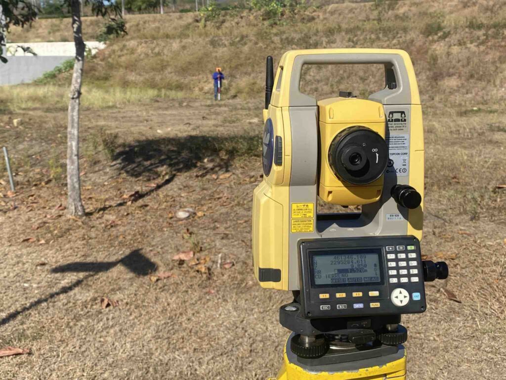
Traditional ground surveying methods, while accurate at specific points, face significant limitations in coverage and frequency. Survey teams can only measure limited locations, creating data gaps that may miss critical subsidence areas.
Weather dependency, accessibility issues, and safety concerns further limit traditional surveying effectiveness. Early warning systems for building stability require comprehensive, frequent monitoring that conventional methods cannot economically provide.
GPS Monitoring vs Satellite Radar
While GPS monitoring provides point-specific accuracy, satellite monitoring for construction safety offers comprehensive area coverage. GPS stations require physical installation and maintenance, limiting deployment in hazardous or inaccessible areas.
DInSAR complements GPS monitoring by providing context and identifying areas where additional ground-based sensors might be needed. This combination approach maximizes both coverage and precision for critical infrastructure protection.
Cost and Time Efficiency Comparison
Economic analysis shows DInSAR for ground subsidence monitoring provides superior cost-effectiveness for large-area monitoring. Initial setup costs are lower than establishing extensive ground-based monitoring networks, while operational costs remain consistent regardless of site complexity.
Traditional surveying costs scale linearly with area size and monitoring frequency, making comprehensive monitoring prohibitively expensive for many projects. DInSAR maintains consistent costs while providing exponentially more data points and coverage.
Early Warning Systems for Ground Subsidence
Real-Time Deformation Detection
Modern early warning systems for building stability integrate DInSAR data with automated analysis algorithms to identify dangerous deformation trends. These systems can detect acceleration in subsidence rates, triggering immediate alerts to construction teams and safety personnel.
Threshold-based monitoring compares current deformation rates against established safety parameters. When subsidence exceeds predetermined limits, the system automatically generates warnings, enabling proactive intervention before structural damage occurs.
🚨 Alert System Workflow
Data Collection
Analysis
Alert
Action
Threshold Setting and Alert Mechanisms
Effective preventing ground subsidence in construction requires carefully calibrated alert thresholds based on soil conditions, structure types, and safety margins. Multi-level warning systems provide graduated responses from monitoring increases to construction halts.
Alert mechanisms include email notifications, SMS alerts, dashboard warnings, and integration with construction management systems. This multi-channel approach ensures critical information reaches decision-makers promptly, regardless of their location or communication preferences.
Integration with Construction Management
What is DInSAR technology used for in construction management extends beyond simple monitoring to comprehensive risk management integration. Modern systems connect deformation data with project schedules, weather forecasts, and construction activities to provide holistic risk assessment.
This integration enables predictive analysis, identifying periods of increased subsidence risk based on construction activities, seasonal patterns, and environmental conditions. Project managers can adjust schedules and implement protective measures proactively.
Applications in Construction Projects
Foundation Monitoring and Safety
Foundation stability represents the most critical application for monitoring ground subsidence using DInSAR. Continuous monitoring during excavation and construction phases ensures foundation integrity and identifies potential settlement issues before they compromise structural safety.
Deep foundation projects particularly benefit from comprehensive area monitoring, as DInSAR can detect differential settlement patterns that might not be apparent from point measurements alone. This capability prevents costly foundation repairs and ensures long-term structural stability.
Infrastructure Stability Assessment
Large infrastructure projects require extensive ground subsidence monitoring with satellite radar due to their scale and complexity. Bridges, tunnels, and major buildings generate significant loads that can trigger subsidence in susceptible soils.
DInSAR monitoring provides essential data for load distribution optimization and construction sequencing. By understanding ground response patterns, engineers can modify construction methods to minimize subsidence risk and ensure infrastructure longevity.
Coastal Construction Challenges
Coastal construction environments present unique subsidence challenges due to soft marine soils, tidal influences, and seasonal variations. Satellite monitoring for construction safety becomes essential in these environments where traditional monitoring may be impractical or unsafe.
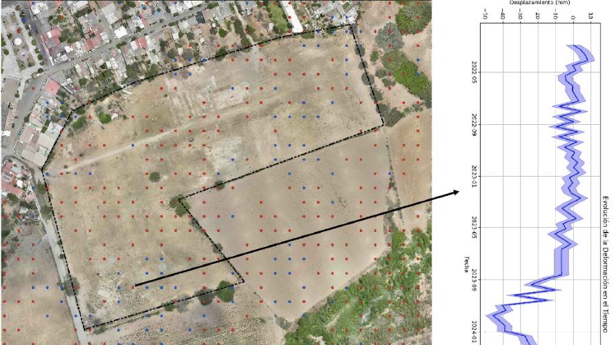
Puerto Vallarta’s coastal development projects exemplify how DInSAR monitoring addresses these challenges, providing reliable data despite challenging environmental conditions and ensuring construction safety in marine-influenced soils.
Ready to implement advanced ground monitoring for your construction project? Get expert consultation from GeoScience.
DInSAR Technology Components
Sentinel-1 and Commercial Satellites
The European Space Agency’s Sentinel-1 constellation provides the foundation for most DInSAR ground subsidence monitoring applications. These satellites offer free, regular coverage with 6-12 day repeat cycles, making comprehensive monitoring economically feasible for construction projects.
Commercial satellites like TerraSAR-X and COSMO-SkyMed complement Sentinel-1 with higher resolution and more frequent revisits for critical infrastructure monitoring. The combination of free and commercial data sources optimizes both coverage and precision for specific project requirements.
Processing Software and Algorithms
Advanced processing algorithms transform raw satellite data into actionable subsidence information. How to detect ground movement early depends on sophisticated software that can identify subtle phase changes and filter atmospheric effects from actual ground deformation.
Professional processing services utilize specialized software like GAMMA, SNAP, and commercial platforms that require significant expertise to operate effectively. The complexity of processing makes professional services essential for reliable results.
Ground Control Points Integration
Ground control points enhance DInSAR for ground subsidence monitoring accuracy by providing reference coordinates for satellite data calibration. Strategic placement of control points across construction sites ensures optimal accuracy and validates satellite-derived measurements.
Integration with existing survey networks maximizes data utility and ensures consistency with traditional surveying references. This integration approach combines the comprehensive coverage of DInSAR with the precision of ground-based measurements.
Case Studies: Successful Implementation
Puerto Vallarta Coastal Development
A major coastal resort development implemented satellite monitoring for construction safety to address challenging marine soil conditions. The project utilized DInSAR monitoring to track foundation performance and optimize construction sequencing for minimal environmental impact.
Results showed early detection of settlement patterns that enabled proactive foundation reinforcement, preventing potential structural issues and ensuring project completion on schedule. The monitoring system provided crucial data for environmental compliance and stakeholder reporting.
Mexico City Infrastructure Monitoring
Mexico City’s subway expansion project employed monitoring ground subsidence using DInSAR to ensure safe tunneling operations in the city’s notoriously unstable soils. Comprehensive area monitoring identified subsidence patterns that informed tunneling methods and surface protection measures.
The implementation prevented surface damage to existing structures while ensuring worker safety during excavation. Real-time monitoring enabled immediate response to changing ground conditions, maintaining project safety and schedule adherence.
Mining Operations Subsidence Control
A large mining operation utilized ground subsidence monitoring with satellite radar to track environmental impacts and ensure operational safety. The system monitored both active mining areas and surrounding communities to detect any adverse effects from extraction activities.
Early warning capabilities enabled proactive intervention when subsidence rates exceeded acceptable limits, demonstrating corporate responsibility while maintaining operational efficiency. The monitoring data also supported environmental compliance reporting and community relations.
ROI and Risk Mitigation Benefits
Preventing Construction Disasters
Early warning systems for building stability provide exceptional return on investment by preventing catastrophic failures that could cost millions in damages, delays, and liability. Early detection enables corrective action before problems become critical.
Insurance companies increasingly recognize the value of proactive monitoring, offering reduced premiums for projects implementing comprehensive ground monitoring systems. This risk reduction approach protects both immediate project investments and long-term asset values.
Insurance and Liability Reduction
Comprehensive preventing ground subsidence in construction documentation provides essential protection against liability claims and insurance disputes. Objective monitoring data demonstrates due diligence and proactive risk management practices.
Professional monitoring services also provide expert testimony and technical support for insurance claims and legal proceedings, protecting project stakeholders from unfounded liability claims and ensuring fair resolution of legitimate issues.
Long-term Monitoring Economics
What is DInSAR technology used for extends beyond immediate construction safety to long-term asset management and maintenance planning. Continuous monitoring provides baseline data for future renovations, expansions, and maintenance decisions.
The accumulated monitoring data becomes a valuable asset for property owners, providing objective documentation of ground stability trends that inform long-term investment and maintenance strategies.
Implementation Guide for Construction Companies
Assessment and Planning Phase
Successful DInSAR ground subsidence monitoring implementation begins with thorough site assessment and risk evaluation. Professional evaluation identifies specific monitoring requirements, optimal satellite data sources, and integration opportunities with existing project management systems.
Planning considerations include monitoring frequency, alert thresholds, reporting requirements, and integration with construction schedules. Proper planning ensures monitoring systems provide maximum value while minimizing operational disruption.
Service Provider Selection
Choosing qualified providers for how to monitor ground subsidence with DInSAR requires evaluation of technical capabilities, processing expertise, and local experience. Look for providers with demonstrated experience in construction applications and appropriate certifications.
Local expertise proves particularly valuable for understanding regional soil conditions, regulatory requirements, and environmental factors that affect monitoring accuracy and interpretation. Regional providers also offer better response times and ongoing support.
Data Integration Workflows
Effective integration of satellite monitoring for construction safety data requires compatible workflows with existing project management systems. Modern monitoring platforms offer API integration and standardized reporting formats that streamline data utilization.
Training programs ensure project teams can effectively interpret and act on monitoring data. Successful implementation requires both technical integration and human capacity development for optimal results.
Future of Subsidence Monitoring Technology
AI-Enhanced Detection Systems
Artificial intelligence is revolutionizing detecting ground movement early through automated pattern recognition and predictive analytics. Machine learning algorithms can identify subtle changes that might escape human analysis, improving detection sensitivity and reducing false alarms.
AI systems also enable predictive modeling that forecasts future subsidence trends based on current patterns, weather data, and construction activities. This predictive capability represents the next evolution in proactive risk management.
Real-Time Processing Advances
Emerging technologies promise near real-time DInSAR for ground subsidence monitoring with processing times measured in hours rather than days. Cloud computing and improved algorithms enable faster analysis and more responsive early warning systems.
Real-time capabilities particularly benefit dynamic construction environments where rapid response to changing conditions is essential for safety and project success. This technology evolution makes DInSAR monitoring even more valuable for construction applications.
Integration with IoT Sensors
Future monitoring systems will integrate ground subsidence monitoring with satellite radar data with IoT sensors, weather stations, and construction monitoring systems. This comprehensive approach provides holistic site awareness and enhanced predictive capabilities.
Integrated systems will automatically correlate multiple data sources to provide more accurate risk assessment and enable more sophisticated automated responses to changing site conditions.
Frequently Asked Questions
Q: How accurate is DInSAR compared to traditional surveying?
A: DInSAR ground subsidence monitoring achieves 1-2mm precision across entire sites, while traditional surveying provides higher accuracy at specific points but limited coverage.
Q: What’s the minimum detectable movement?
A: Modern systems can detect movements as small as 1-2 millimeters, making early warning systems for building stability highly sensitive to initial subsidence signs.
Q: How often is monitoring data updated?
A: Sentinel-1 satellites provide updates every 6-12 days, while commercial satellites can offer daily monitoring for critical projects requiring satellite monitoring for construction safety.
❓ Need Specific Answers?
Consult with our DInSAR monitoring specialists at GeoScience
Q: Can DInSAR work in all weather conditions?
A: Yes, monitoring ground subsidence using DInSAR works regardless of weather since radar penetrates clouds and operates day or night.
Q: What’s the cost compared to traditional monitoring?
A: Ground subsidence monitoring with satellite radar typically costs 30-50% less than equivalent traditional surveying while providing comprehensive area coverage.
Implementing how to monitor ground subsidence with DInSAR technology represents a significant advancement in construction safety and risk management. This technology enables proactive identification of ground stability issues before they become critical, protecting both immediate project investments and long-term infrastructure integrity. As satellite technology continues advancing, DInSAR monitoring will become increasingly essential for responsible construction practices worldwide.