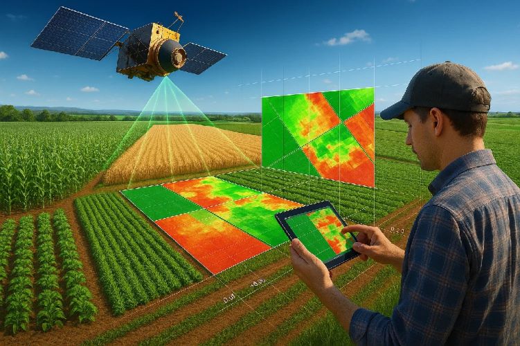
Satellite remote sensing for agriculture has revolutionized modern farming by providing unprecedented insights into crop health, soil conditions, and environmental factors. This advanced technology enables farmers to monitor vast agricultural areas with precision, optimize resource usage, and increase yields while reducing costs. How to use satellite remote sensing for agriculture involves understanding vegetation indices, interpreting multispectral data, and implementing precision agriculture techniques that transform traditional farming practices.
Agricultural professionals worldwide are adopting crop monitoring with satellite technology to address challenges like climate variability, resource scarcity, and food security demands. This comprehensive guide explores practical applications, implementation strategies, and economic benefits of satellite-based agricultural monitoring systems.
What is Satellite Remote Sensing in Agriculture?
Understanding Agricultural Remote Sensing Technology
Remote sensing for precision agriculture utilizes satellites equipped with specialized sensors to capture electromagnetic radiation reflected from crops and soil. These sensors detect wavelengths invisible to human eyes, revealing crucial information about plant health, stress levels, and growth patterns.
The technology works by analyzing how crops reflect different wavelengths of light. Healthy vegetation strongly reflects near-infrared radiation while absorbing visible red light for photosynthesis. This characteristic spectral signature enables satellite technology for farm management to assess crop conditions across entire fields simultaneously.
Multispectral Monitoring
Analyze 13+ spectral bands for comprehensive crop assessment
Real-Time Analysis
Monitor crop conditions every 3-5 days with automated alerts
Precision Insights
Identify issues before visible symptoms appear
How Satellites Monitor Crop Health
Satellites capture data through passive sensors that measure reflected solar radiation and active sensors that emit their own signals. Agricultural monitoring systems process this data to create detailed maps showing vegetation health, moisture levels, and stress indicators across entire farms.
The monitoring process involves systematic data collection, atmospheric correction, and vegetation index calculation. Advanced algorithms convert raw satellite data into actionable agricultural intelligence, enabling farmers to make informed decisions about irrigation, fertilization, and pest management.
Key Benefits for Modern Farming
Precision agriculture with satellite data offers numerous advantages over traditional field scouting methods. Farmers can monitor large areas efficiently, detect problems early, and optimize input applications based on precise spatial data rather than field averages.
Cost reduction through targeted resource application represents one of the most significant benefits. Instead of uniform treatment across entire fields, farmers can apply water, fertilizer, and pesticides only where needed, reducing costs while minimizing environmental impact.
Types of Agricultural Satellite Monitoring
Multispectral Imaging for Crop Analysis
Multispectral satellites capture data across multiple wavelength bands, each providing specific information about crop conditions. Crop monitoring using remote sensing typically utilizes visible, near-infrared, and shortwave infrared bands to calculate vegetation indices and assess plant health.
These indices include NDVI (Normalized Difference Vegetation Index), which indicates photosynthetic activity and biomass, and NDWI (Normalized Difference Water Index), which reveals plant water stress. Advanced systems also monitor chlorophyll content, leaf area index, and canopy structure.
Thermal Sensors for Water Stress Detection
Thermal infrared sensors detect crop water stress by measuring leaf temperature differences. Stressed plants close their stomata to conserve water, reducing transpiration and increasing leaf temperature. Remote sensing applications in farming use this principle to identify irrigation needs before visual stress symptoms appear.
Water stress detection proves particularly valuable in arid and semi-arid regions where irrigation management directly impacts yield and profitability. Early detection enables proactive irrigation scheduling, preventing yield losses while optimizing water usage.
Radar Monitoring for Soil Conditions
Synthetic Aperture Radar (SAR) satellites penetrate clouds and vegetation canopy to monitor soil moisture, surface roughness, and crop structure. Satellite technology for farm management integrates radar data with optical imagery for comprehensive field assessment regardless of weather conditions.
Radar monitoring proves especially valuable during cloudy seasons when optical satellites cannot capture clear images. This capability ensures continuous monitoring throughout growing seasons, providing consistent data for decision-making.
Crop Health Analysis with Satellite Data
Vegetation Indices (NDVI, EVI, SAVI)
Vegetation indices transform multispectral data into meaningful crop health indicators. NDVI ranges from -1 to +1, with healthy vegetation typically showing values between 0.3 and 0.8. How to use satellite remote sensing for agriculture effectively requires understanding these indices and their seasonal variations.
EVI (Enhanced Vegetation Index) provides improved sensitivity in high biomass areas where NDVI may saturate. SAVI (Soil-Adjusted Vegetation Index) accounts for soil background influence, particularly useful during early growth stages when soil exposure affects measurements.
Disease and Pest Detection
Agricultural monitoring systems can detect disease and pest infestations before visible symptoms appear by identifying subtle changes in spectral reflectance patterns. Stressed plants exhibit altered chlorophyll content and cellular structure, creating distinctive spectral signatures detectable by satellite sensors.
Early detection enables targeted treatment applications, reducing pesticide usage and preventing widespread infestations. This capability proves particularly valuable for high-value crops where early intervention can prevent significant economic losses.
Nutrient Deficiency Identification
Nutrient deficiencies create specific spectral signatures as they affect chlorophyll production and leaf structure. Precision agriculture with satellite data can identify nitrogen, phosphorus, and potassium deficiencies through spectral analysis, enabling precise fertilizer applications.
Nitrogen deficiency appears as reduced near-infrared reflectance and increased visible reflectance, while phosphorus deficiency affects specific wavelength ratios. This information guides variable rate fertilizer applications, optimizing nutrient management while reducing environmental impact.
Precision Agriculture Applications
Variable Rate Application Mapping
Crop monitoring using remote sensing generates prescription maps for variable rate application of seeds, fertilizers, and pesticides. These maps divide fields into management zones based on crop health, soil conditions, and historical yield data.
Variable rate technology can increase yields by 5-15% while reducing input costs by 10-20%. The precision achieved through satellite guidance ensures optimal resource distribution, addressing field variability that uniform applications cannot accommodate.
Irrigation Management and Water Optimization
Satellite-derived water stress indicators guide irrigation scheduling and water allocation decisions. Remote sensing applications in farming provide field-scale water stress maps, enabling precision irrigation that applies water only where and when needed.
Smart irrigation systems integrate satellite data with weather forecasts and soil moisture sensors to optimize water usage. This approach can reduce water consumption by 20-30% while maintaining or improving yields, particularly crucial in water-scarce regions.
Ready to optimize your agricultural operations with advanced satellite monitoring? Contact GeoScience for expert consultation.
Yield Prediction and Harvest Planning
Satellite monitoring enables accurate yield predictions by correlating vegetation indices with historical yield data. Satellite technology for farm management provides early season yield estimates that improve planning for harvest logistics, storage, and marketing decisions.
Yield mapping helps farmers optimize harvest timing, equipment allocation, and labor scheduling. Accurate predictions also support crop insurance claims and enable better negotiation with buyers through reliable quantity forecasts.
Satellite Platforms for Agricultural Monitoring
Sentinel-2 for Free Crop Monitoring
The European Space Agency’s Sentinel-2 constellation provides free, high-resolution agricultural monitoring with 10-meter spatial resolution and 5-day revisit frequency. How to use satellite remote sensing for agriculture cost-effectively often begins with Sentinel-2 data access through platforms like Google Earth Engine.
Sentinel-2’s 13 spectral bands cover visible, near-infrared, and shortwave infrared wavelengths optimal for vegetation analysis. The free data access democratizes precision agriculture, making advanced monitoring available to farms of all sizes.
Commercial High-Resolution Options
Commercial satellites like Planet Labs, Maxar, and Airbus offer sub-meter resolution and daily revisit capabilities for intensive monitoring applications. These platforms provide enhanced detail for high-value crops and research applications requiring maximum precision.
While commercial options involve subscription costs, they offer superior spatial and temporal resolution for critical monitoring needs. The investment often justifies itself through improved crop management and risk reduction for valuable agricultural operations.
Real-Time vs Historical Data Analysis
Agricultural monitoring systems benefit from both real-time monitoring for immediate decision-making and historical analysis for trend identification. Real-time data enables rapid response to stress events, while historical analysis reveals long-term patterns and optimal management strategies.
Combining current conditions with historical baselines provides context for interpreting satellite data. This approach improves accuracy in identifying abnormal conditions and predicting crop responses to management interventions.
Implementation Guide for Farmers
Choosing the Right Monitoring Solution
Selecting appropriate satellite remote sensing for agriculture solutions depends on farm size, crop types, management intensity, and budget constraints. Small farms may benefit from free platforms, while large commercial operations often require comprehensive commercial solutions.
Key considerations include spatial resolution requirements, monitoring frequency needs, data processing capabilities, and integration with existing farm management systems. Professional consultation helps optimize technology selection for specific agricultural applications.
Integration with Farm Management Systems
Modern precision agriculture with satellite data requires seamless integration with existing farm management information systems (FMIS). APIs and data standards enable automatic data transfer between satellite platforms and farm software.
Integration streamlines workflows by automatically updating crop monitoring dashboards, generating alerts, and creating prescription maps. This connectivity eliminates manual data handling and ensures timely access to critical information.
Cost-Benefit Analysis for Different Farm Sizes
Economic benefits of crop monitoring with satellite technology vary significantly with farm size and crop value. Large operations typically achieve faster return on investment through economies of scale, while smaller farms benefit from reduced per-hectare monitoring costs.
💰 ROI by Farm Size
Small Farms (10-50 ha)
Input cost reduction
Medium Farms (50-200 ha)
Total ROI improvement
Large Farms (200+ ha)
Comprehensive optimization
Case Studies: Successful Agricultural Monitoring
Mexican Avocado Plantations Success Story
A major avocado operation in Michoacán implemented satellite technology for farm management to optimize irrigation and detect early signs of root rot disease. The system monitored 500 hectares of avocado trees using weekly Sentinel-2 data and bi-weekly high-resolution commercial imagery.
Results showed 30% reduction in water usage through precision irrigation scheduling and early detection of disease outbreaks that prevented spread to 40% of the plantation. The investment paid for itself within one growing season through reduced losses and optimized resource usage.
Corn and Soybean Monitoring in Nayarit
A cooperative of corn and soybean farmers in Nayarit adopted agricultural monitoring systems to improve yield consistency across varied field conditions. The program covered 2,000 hectares and utilized variable rate seeding and fertilization based on satellite-derived vigor maps.
Implementation resulted in 18% average yield increase and 25% reduction in fertilizer costs. Farmers reported improved decision-making confidence and better understanding of field variability patterns that guided long-term soil improvement strategies.
Tropical Fruit Cultivation Optimization
A mango and papaya operation near Puerto Vallarta used remote sensing applications in farming to optimize irrigation timing and detect nutrient stress in tropical fruit orchards. The challenging humid climate required specialized interpretation of satellite data.
The monitoring system identified optimal harvest timing windows and prevented over-irrigation that previously caused root problems. Quality improvements and reduced losses generated 40% return on investment in the first year of implementation.
ROI and Economic Benefits
Reduced Input Costs Through Precision Application
Precision agriculture with satellite data typically reduces fertilizer, pesticide, and water usage by 15-30% through targeted applications based on actual crop needs rather than field averages. These savings directly impact profitability while supporting environmental sustainability goals.
Variable rate applications guided by satellite data ensure resources reach areas where they provide maximum benefit. This optimization prevents waste in areas with low crop potential while ensuring adequate supplies in high-performing zones.
Increased Yields and Quality Improvements
Satellite monitoring enables optimal timing for all agricultural operations, from planting and fertilization to irrigation and harvest. Crop monitoring using remote sensing provides objective data for decision-making, removing guesswork from critical management decisions.
Yield improvements of 10-25% are common when satellite monitoring guides precision agriculture practices. Quality improvements often prove even more valuable, particularly for premium crops where slight improvements in grade command significant price premiums.
Risk Management and Insurance Benefits
Comprehensive agricultural monitoring systems provide documentation for crop insurance claims and enable proactive risk management. Early detection of stress conditions allows intervention before permanent damage occurs, reducing insurance claims and maintaining production consistency.
Comprehensive agricultural monitoring systems provide documentation for crop insurance claims and enable proactive risk management. Early detection of stress conditions allows intervention before permanent damage occurs, reducing insurance claims and maintaining production consistency.
Some insurance providers offer premium discounts for farms using satellite monitoring systems, recognizing the reduced risk associated with proactive management. This benefit adds to the economic value of monitoring technology adoption.
Future of Agricultural Satellite Technology
AI-Powered Crop Analysis
Artificial intelligence is revolutionizing how to use satellite remote sensing for agriculture through automated pattern recognition and predictive analytics. Machine learning algorithms can identify subtle stress patterns that escape human analysis, improving detection accuracy and response speed.
AI systems will eventually provide real-time recommendations for optimal management actions based on current satellite data, weather forecasts, and historical performance patterns. This capability represents the future of fully automated precision agriculture systems.
Real-Time Alert Systems
Emerging technologies promise near real-time agricultural monitoring with processing times measured in hours rather than days. Cloud computing and improved algorithms enable immediate analysis and automated alert generation for critical crop conditions.
Real-time capabilities particularly benefit time-sensitive applications like irrigation scheduling and pest management, where rapid response significantly impacts outcomes. This technology evolution makes satellite monitoring even more valuable for dynamic agricultural environments.
Integration with Drone and IoT Data
Future agricultural monitoring will seamlessly integrate satellite remote sensing for agriculture with drone imagery, ground sensors, and IoT devices. This multi-scale approach provides comprehensive farm intelligence from broad-scale satellite coverage to detailed ground-truth validation.
Integrated systems will automatically correlate data from multiple sources to provide holistic farm management insights and enable sophisticated automated responses to changing field conditions.
Frequently Asked Questions
Q: How accurate is satellite monitoring compared to field scouting?
A: Satellite remote sensing for agriculture provides objective, repeatable measurements across entire fields, while traditional scouting covers limited sample points. Satellite monitoring detects issues 1-2 weeks before visual symptoms appear.
Q: What’s the minimum farm size for cost-effective satellite monitoring?
A: Agricultural monitoring systems become cost-effective for farms as small as 10 hectares, though larger operations (50+ hectares) typically see faster return on investment through economies of scale.
Q: Can satellite monitoring work during cloudy weather?
A: Crop monitoring with satellite technology uses both optical and radar satellites. While optical sensors require clear skies, radar penetrates clouds, ensuring continuous monitoring regardless of weather conditions.
Q: How often is agricultural satellite data updated?
A: Remote sensing applications in farming typically provide updates every 3-5 days with free satellites like Sentinel-2, while commercial platforms can offer daily monitoring for critical applications.
🌾 Ready to Revolutionize Your Farming?
Get personalized agricultural monitoring solutions from GeoScience experts
Q: What crops benefit most from satellite monitoring?
A: Precision agriculture with satellite data benefits all crop types, but high-value crops like fruits, nuts, and vegetables see fastest ROI. Field crops like corn and soybeans benefit through optimized input applications.
Q: Do I need special software to use satellite data?
A: Many satellite technology for farm management platforms provide user-friendly interfaces requiring no technical expertise. Professional services can also process data and deliver actionable insights directly to farmers.
Implementing how to use satellite remote sensing for agriculture represents a transformative step toward sustainable, profitable farming. This technology enables data-driven decision-making that optimizes resource usage, increases yields, and reduces environmental impact. As satellite technology continues advancing with AI integration and real-time processing, agricultural monitoring will become increasingly essential for competitive farming operations worldwide.
The future of agriculture depends on precision management techniques that satellite remote sensing enables. Farmers who adopt these technologies today position themselves for long-term success in an increasingly challenging agricultural environment where efficiency and sustainability determine profitability.